Date of Formation: Jamtara District was carved out of Dumka District on 26th April 2001.
Area: 1802 square kilometers
Density of Population: 439 people per square kilometer
Literacy Rate: 63.73 % - Male: 76.85 %, Female: 50.08 %
Male Female Ratio: 1000:959
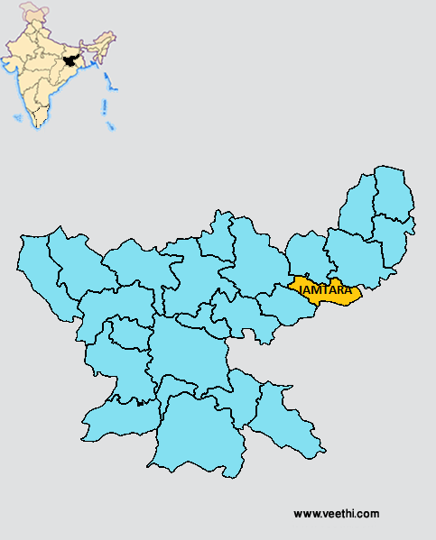
Boundaries of Jamtara District
North: Deogarh District and Dumka District, Jharkhand
South West: Dhanbad District, Jharkhand
South East and East: West Bengal
West: Dhanbad District, Jharkhand
Jamtara District Average Rainfall: 1121 mm
Jamtara District Average Temperature in Summer: 31 deg C
Jamtara District Average Temperature in Winter: 18 deg C
JAMTARA DISTRICT MAP

Major Rivers: River Ajay, Brakar River
Sub Divisions: Jamtara
Blocks: Jamtara, Kundahit, Nala, Narayanpur
Assembly Constituencies: Sarath, Jamtara, Nala
Jamtara District Nearby Attractions
1. Parwat Vihar Park
2. Chanchala Mandir
3. Devleshwar Dham
4. Dukhiya Mahadeo Mandir
5. Singh Vahini Mandir
6. S.D.A. Mission Karmatar
7. Vivekanand Ashram
8. Hanuman Mandir
9. Children Park
Jamtara District Facts: This is one of the 21 most backward districts of Jharkhand that is receiving funds from the Backward Regions Grant Fund Program.
Major Agricultural Products: Paddy, wheat, maize
Major Industrial Products: Ferro alloys, iron, biscuits, soap, chocolate, tiles
Major Educational Institutions: Jamtara College, Jamtara Mahila College, JBC High School
What is Jamtara District Famous For: DALDA
Last Updated : Monday Jun 11 , 2012


.jpeg)


